

I have lived in Huntersville my entire life, and my family’s roots in this area stretch back eight generations. Whenever people learn that, they often ask me the same question:
“What was life like before the lake?”
That simple question inspired me to begin researching the history of our area. Before Lake Norman existed, families lived, worked, worshipped, and built thriving communities along the Catawba River. Many of those stories have been forgotten with time.
Life Before The Lake is a series dedicated to uncovering and sharing those stories. Through articles featured on LKNConnect, we’ll explore the people, places, and events that shaped our region long before the waters of Lake Norman transformed the landscape.
I invite you to join me as we discover the history of the communities that came before the lake.
This article tells the story of the actual construction of Lake Norman, but for me, it is more than just history—it is a childhood memory.
I was four years old when construction began on what would become North Carolina’s largest man-made lake. At the time, my family lived only about a half-mile from the future shoreline, at the corner of Beatties Ford Road and Gilead Road—a place I still call home today.
As a young boy, I was fascinated by the enormous machines that seemed to take over the countryside. Day after day, I watched crews clear-cut thousands of acres of land that would eventually disappear beneath the water. The sounds of bulldozers and heavy equipment became a familiar part of life.
What I remember most was the smoke. After the trees and brush were cleared, workers piled the debris into massive stacks and burned it. For months, columns of smoke rose above the landscape, a constant reminder that the land was being transformed forever.
Another memory that stands out was the effort to control mosquitoes as the lake began to take shape. Trucks regularly drove through the area, spraying insecticide to reduce mosquito populations around the construction site and nearby communities.
At four years old, I could not fully understand the magnitude of what was happening. I simply knew that something big was taking place just beyond my backyard. Looking back today, I realize I was witnessing one of the most significant changes in the history of our region—the creation of Lake Norman.
The idea that would eventually create Lake Norman began decades before the first shovel of dirt was moved.
In the 1890s, an engineer involved with the development of hydroelectric power at Niagara Falls recognized the untapped potential of the Catawba River. In 1905, he presented the concept of harnessing the river’s power through a series of dams to industrialist James Buchanan Duke. Duke embraced the vision and provided the financial backing needed to launch the project through the Catawba Power Company.
Over the next several decades, a chain of hydroelectric lakes gradually transformed the Catawba River. Lake Norman would become the seventh and largest reservoir in the system—the crowning achievement of a plan that had been taking shape for more than half a century.
Long before construction began, Duke Power quietly acquired thousands of acres throughout the river valley. Beginning in the 1920s, the company purchased farms, woodlands, and riverfront property that would eventually lie beneath the lake’s waters. By the 1950s, nearly all of the land required for the massive project had been secured.
Among those who sold property was local resident Wib Overcash and his family. The land, which had been in his wife’s family since the 1700s, represented generations of history and tradition. The family sold 72 acres to Duke Power for approximately $200 per acre, although they wisely retained a portion of the property that would later become valuable waterfront land.
The official beginning of construction arrived in September 1959 with a ceremony that drew excitement from across the region. Governor Luther H. Hodges had the honor of detonating the ceremonial dynamite charge that marked the start of the project. Nearly 1,000 spectators gathered to witness the historic moment. The Mooresville High School Band provided a festive fanfare while Duke Power employees worked to keep the enthusiastic crowd at a safe distance from the blast site.
As the dynamite echoed across the countryside, few could fully appreciate the transformation that was about to unfold. Farms, forests, roads, and entire communities would soon give way to rising waters, creating a lake that would forever change the landscape—and the future—of the Lake Norman region.
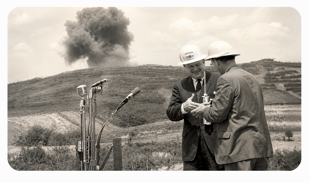
W.B McGuire and S.C Governor McNair

Luther Hodges and W.B. McGuire
Creating Lake Norman was one of the largest construction projects ever undertaken in the Piedmont of North Carolina. What began as a vision on paper soon became a massive undertaking that transformed thousands of acres of countryside into the lake we know today.
For four years, the landscape echoed with the sounds of bulldozers, chainsaws, blasting operations, and concrete mixers. Between 1,200 and 1,500 engineers, laborers, equipment operators, and managers worked tirelessly to bring the project to life. Their responsibilities ranged from surveying land and making complex engineering calculations to clearing forests, relocating roads, and pouring the enormous quantities of concrete needed to construct the dam.
The scale of the undertaking was staggering. Entire sections of the river valley had to be cleared and prepared before the waters could begin to rise. Every phase of the project required careful planning and coordination, as workers raced against time and nature to complete one of the most ambitious hydroelectric projects in the Southeast.
Duke Power invested approximately $62 million in the construction of the lake and dam system—a remarkable sum in the late 1950s and early 1960s. Adjusted for inflation, that investment would equal roughly $481 million today. It was a bold commitment that reflected the company’s confidence in the region’s future growth and the importance of hydroelectric power to North Carolina’s expanding economy.
By the time the project was completed, the combined efforts of thousands of workers and decades of planning had transformed the Catawba River forever, creating a lake that would become one of the defining landmarks of the region.
.Back to our story
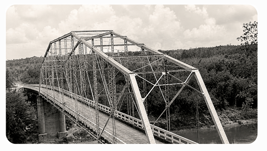
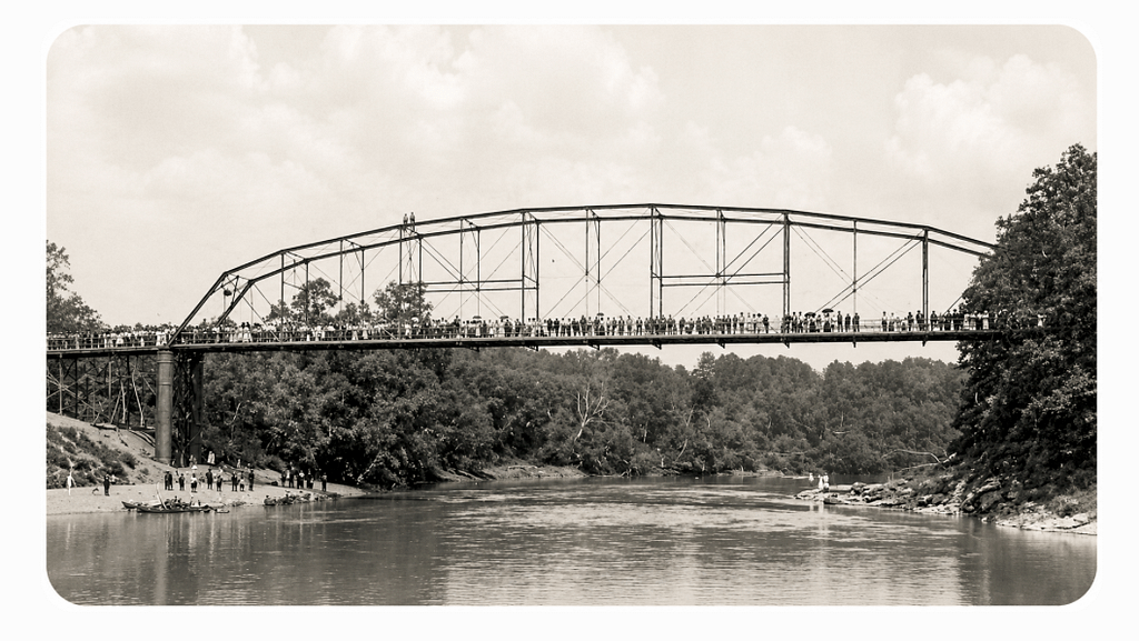
This photograph captures the first bridge to span the Catawba River, taken sometime after its completion. Viewed from a nearby hillside, the image offers a rare glimpse into a structure that once served as a vital link between communities on either side of the river.
The photograph reveals the bridge’s original roadbed resting atop a framework of heavy steel beams, a testament to the engineering and craftsmanship of the era. At the time, the bridge represented progress and connectivity, providing residents, farmers, and merchants with a dependable crossing over the often unpredictable waters of the Catawba.
For years, the bridge stood as an important transportation route and a familiar landmark along the river. Yet its life would be cut short by one of the most devastating natural disasters in North Carolina history.
In July 1916, torrential rains from two powerful storms unleashed catastrophic flooding throughout the Catawba River Valley. As floodwaters surged downstream, bridges, homes, mills, and entire sections of roadway were swept away. The mighty Catawba River bridge was among the casualties, destroyed by the raging waters of the Great Flood of 1916.
Today, photographs like this one serve as a reminder of both the ingenuity of those who built the bridge and the tremendous force of the flood that erased it from the landscape. Though the structure is long gone, its story remains an important chapter in the history of the Catawba River and the communities that once depended upon it.
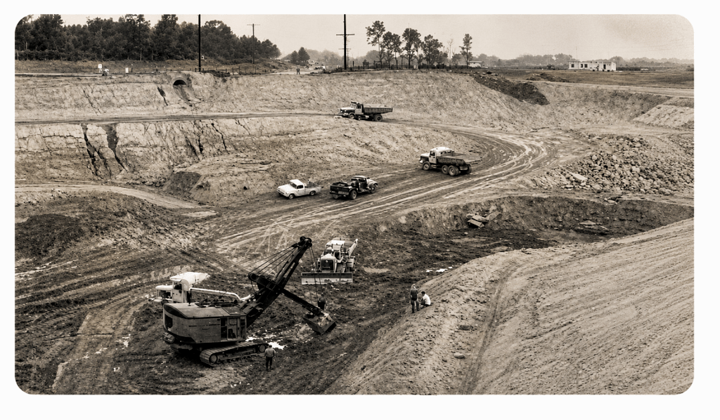
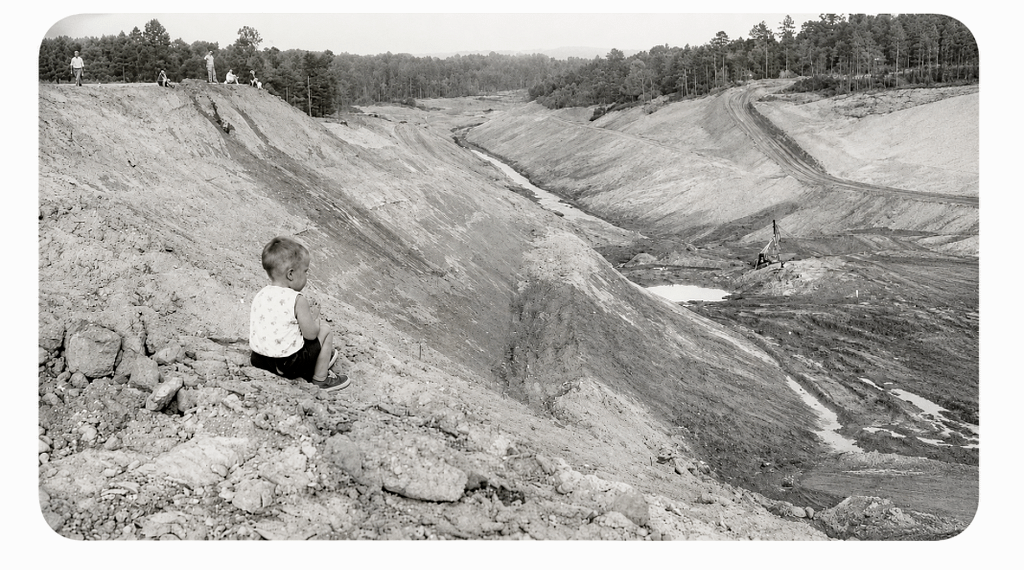
This photograph captures one of the earliest and most demanding phases of the Lake Norman project—clearing the land that would eventually lie beneath the lake’s waters.
Before the reservoir could be filled, thousands of acres of forests, fields, and low-lying areas had to be transformed. Teams of workers using bulldozers, chainsaws, and other heavy equipment methodically cleared the landscape, removing trees, brush, and structures that stood in the path of the future lake.
The area shown in this image was more than simply a clearing operation. It was one of several locations excavated as part of the project’s flood-control design. Engineers carefully shaped portions of the lakebed to help manage water levels and provide additional capacity as the reservoir filled. These excavated areas played an important role in regulating the vast amount of water that would eventually be impounded behind Cowans Ford Dam.
For the workers on the ground, it was physically demanding labor carried out on a scale few had ever witnessed. For local residents, it marked the beginning of a dramatic transformation as familiar fields and woodlands slowly gave way to the lake that would forever redefine the region.
Today, images like this offer a rare glimpse into the enormous effort required to create Lake Norman—a reminder that before the water arrived, there was an entire landscape that first had to be cleared, reshaped, and prepared for a new chapter in North Carolina history.
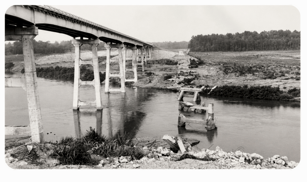
This remarkable photograph captures a unique moment in the history of the Catawba River crossing at Highway 150—a scene where the past and future stood side by side.
Looking north toward Mooresville, the image shows both the remnants of the second Catawba River bridge and its replacement, the third bridge built to accommodate the creation of Lake Norman. The most striking feature is the pair of towers from the older bridge, still standing after the bridge deck had been removed. Like silent sentinels overlooking the river valley, they serve as a reminder of an earlier era when the crossing carried travelers, farmers, and merchants across the Catawba.
The photograph also reveals another piece of history that would soon disappear beneath the rising waters. Visible beside the new bridge is the original Highway 150 roadway, which once followed the natural contours of the land before engineers redesigned the route to account for the higher water levels of the future lake.
As Lake Norman began to take shape, roads, bridges, and transportation routes throughout the region had to be reimagined. Existing infrastructure that had served local communities for decades could no longer meet the demands of a landscape that was about to be transformed by water.
This image preserves that brief transition period when old and new coexisted—a time when the familiar roadways of the Catawba River Valley were giving way to a new transportation network designed for a region on the verge of dramatic change. Today, it stands as a powerful reminder of the engineering challenges and historic transformations that accompanied the creation of Lake Norman.
In 1961, the gravestones of the Cornelius Family Cemetery, which the waters of Lake Norman would have flooded, were relocated from its original location to the Rehobeth United Methodist Church Cemetery in Sherrills Ford, NC. The cemetery contained eight graves, all belonging to members of the Cornelius family. Gravestones ranged in date from 1827 – 1886.
Sources:
Duke Power Co. 19–? (nd). Relocation of Various Cemetery from Area Inundated by the Waters of Lake Norman. Published by Duke Power Co.
I want to recognize Andy Poore, Archivist for Local History & Archives in the Town of Mooresville and the Local History & Archives – Mooresville, North Carolina. I met Andy while researching this and future articles. If you visit their site, you will find great information about Mooresville.
Local History & Archives (LHA) of the Mooresville Public Library
This group serves as the recorded memory of the Town of Mooresville and its surrounding communities and as such is an important part of the community, providing cultural, historical, and genealogical resources and materials. . The types of materials that make up this recorded memory include letters, organizational and business records, Town records, photographs, artifacts, memorabilia, publications, and other documents in various formats. LHA chronicles the development and evolution of Mooresville, and it is essential to the educational mission of LHA to tell an inclusive, responsible, and historically accurate story.
The photos, as well as the descriptions of the photos, were courtesy of their site.
As mentioned, LKNConnect.com aims to report the history of “Life Before The Lake.” We will be researching the past of the towns around the lake and would like to hear from you about your family’s history of the area. Feel free to contact David Beard at Dbeard@Lknconnect.com.
We have attempted to credit all sources for these articles. Much of the information is reported in multiple publications. You can find archived articles at www.Lknconnect.com.
Journalist and historian Chuck McShane provided information for this article. Chuck traced the triumphs and troubles of Lake Norman from the region’s colonial beginnings to its modern incarnation.
Information for this, and upcoming articles on LKNConnect.com, comes from Chuck’s book A History of Lake Norman, published by The History Press, Charleston, SC 29403, Copyright, 2014 by Chuck McShane.
Follow LKNConnect.com for future, short articles from his book, or it can be ordered from your favorite on-line bookstore.